Market expanded. Support costs cut. Twenty years of trust intact.
For nearly two decades, Leica Geosystems’ Safeload has set the standard for rail-car measurement in U.S. rail, but its Windows-only build kept iOS and Android customers out of reach. In one rapid engagement, we rebuilt it for iOS, Android, and Windows from a single codebase, opening the market its customers were asking for, without disrupting the field crews and compliance reporting that built its reputation.
 Click to zoom
Safeload rebuilt for iOS, Android, and Windows, modern in the field, unchanged where compliance lives.
Platforms (iOS, Android, Windows)
Unified Codebase
Field Reference Assets Redesigned
Compliance Trust Preserved
A trusted standard, ready to grow.
For nearly two decades, Safeload has been a trusted standard in U.S. rail. Paired with Leica Geosystems’s Total Station hardware, it guides railroad carmen through precise 3D rail-car measurements, producing the regulatory-compliant reports that keep oversized cargo moving safely.
This wasn’t a product in trouble. It had a strong reputation, a loyal user base, and a clear path to growth, if it could move onto modern platforms without losing what made it valuable.
What Leica Geosystems engaged us to do
- Rebuild Safeload for iOS, Android, and Windows
- Modernize the field experience for real working conditions
- Integrate with the Total Station hardware on the platforms crews actually carry
- Build license management infrastructure for a multi-platform customer base
Client
Leica Geosystems
Industry
Rail & Transportation
Services
UI/UX Design, Native App Development, Hardware Integration, License Management
Platforms
iOS, Android, Windows
Hardware
Leica Geosystems Total Station (GeoCom)
Method
Capabilities
About Leica Geosystems
Founded in 1818 in Heerbrugg, Switzerland, Leica Geosystems (formerly Wild Heerbrugg) is a global market leader in geodetic instruments and precision measurement, serving the geospatial, construction, infrastructure, and mining industries. Since 2005 it has operated as part of Hexagon AB, the Swedish measurement technology company.
Rebuilding established software in a regulated industry is a different category of challenge.
Greenfield development starts from a blank page. This didn’t. Three dynamics make modernization in a regulated industry genuinely difficult, and separate the firms that can do it well from those that can’t.
01
Workflows carry compliance weight
Replicating features isn’t enough. You have to know which workflows produce regulated outputs, and what every change affects downstream, discovery discipline most software firms skip.
02
Zero tolerance for disruption
Field teams aren’t beta testers. When carmen are working on rail cars, the tool has to work the first time, every time. Confusion, retraining, or workflow gaps aren’t a partial success, they’re a problem.
03
Architecture changes more than it appears
Platform expansion hides real engineering. Safeload’s Bluetooth integration wasn’t iOS-compatible at all, so going mobile meant rebuilding the connectivity layer, not porting the UI. Hidden complexity rewards firms that investigate before they estimate.
“They already have everything else on the iPad. They want this on an iPad as well, so they’re not carrying a controller of ours plus their iPad for everything else.”
 Click to zoom
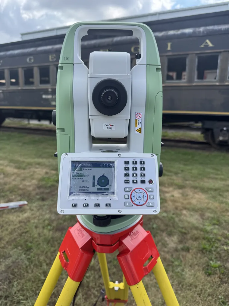
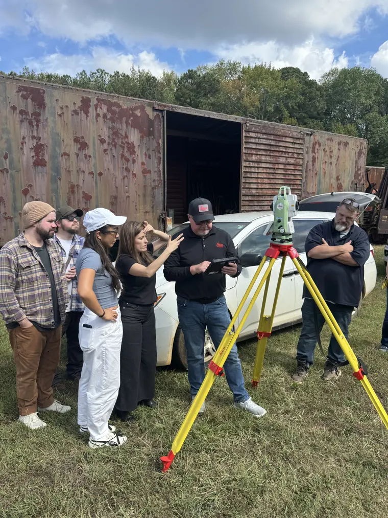
Safeload runs alongside Leica Geosystems’s Total Station, the precision system carmen take trackside.
We started by aligning on the work, not the wireframes.
Before designing anything, our senior product, design-research, and engineering leads ran an alignment workshop with Leica Geosystems to map the product’s reality: who uses it, what they’re trying to accomplish, what the application produces, and what absolutely cannot change.
Vision mapping
A facilitated “where we are / how we get there / where we need to be” exercise to surface the product vision, the device ecosystem, and the risks on the path to a modern, multi-platform Safeload.
The persona: the railroad carman
Not a surveyor. A field worker measuring oversized “high-wide” loads trackside, outdoors, often gloved, who needs the tool to be fast, obvious, and trustworthy. Distinguished by responsibility for safe, compliant clearance, not software fluency.
Field research with a domain SME
We planned direct research with an experienced Class I rail clearance inspector who helped build the original Safeload and knows the workflow end to end, plus observation of a live measurement demo. Research before redesign.
Jobs To Be Done
- When an oversized load arrives in the yard, I want to capture accurate height, width, and length against the rails and car, so I can produce a clearance profile that routing can trust.
- When I’m measuring outdoors in bright sun with gloves on, I want to see the screen and hit the right control the first time, so I can work fast without errors.
- When I get interrupted mid-measurement, I want to pick up exactly where I left off, so I can move across multiple cars without starting over.
- When I finish, I want to generate and hand off a compliant report, so I can keep cargo moving safely and on schedule.
“All our gear is usually outside. Black backgrounds are horrific.”
The field insight that drove the light, high-contrast interface.
The hard part wasn’t the interface. It was the instrument.
Safeload is only as good as its link to the Total Station. The legacy app spoke to the instrument over Bluetooth, which iOS doesn’t support for this purpose. A real port had to solve connectivity first.
The constraint: Leica Geosystems’s instruments don’t natively talk to iOS. Expanding to mobile meant rebuilding the connectivity layer, not porting a screen.
The solve: We built the integration on Leica Geosystems’s GeoCom protocol over WiFi, the tablet and the instrument share a hotspot and exchange angle/distance data, while keeping Bluetooth for existing Windows workflows.
- GeoCom-over-WiFi connectivity for iOS and Android
- Bluetooth retained for existing Windows workflows
- A 19-asset in-app setup guide walking crews through Total Station WiFi configuration, so they get connected without extra support
“Our instruments natively do not talk to an iOS product, but we found a way through Wi-Fi.”
Preserve what works. Expand what’s possible. Sequence everything carefully.
Before designing or building anything, we mapped the compliance-critical workflows and identified what had to remain constant. That clarity became the constraint that shaped every decision, on architecture, interface, workflow, and rollout.
Designed around real working conditions.
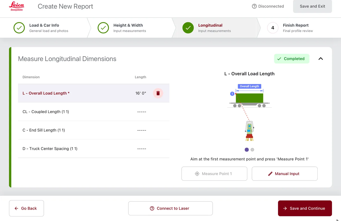
A legacy dark-background interface gives way to a light, high-contrast design built for outdoor visibility and gloved operation. And the 48 field reference assets, the visual guides that help carmen orient the laser at each step, were fully redesigned. In precision work, clear references support accurate measurements, so they got the same rigor as the core app.
 Click to zoom
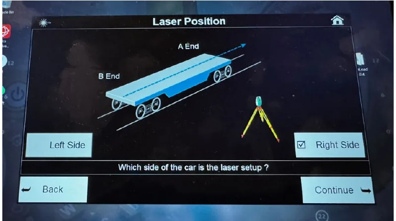
The legacy screen: dark-background, low-contrast, hard to read in sunlight, with small controls difficult to hit with gloves.
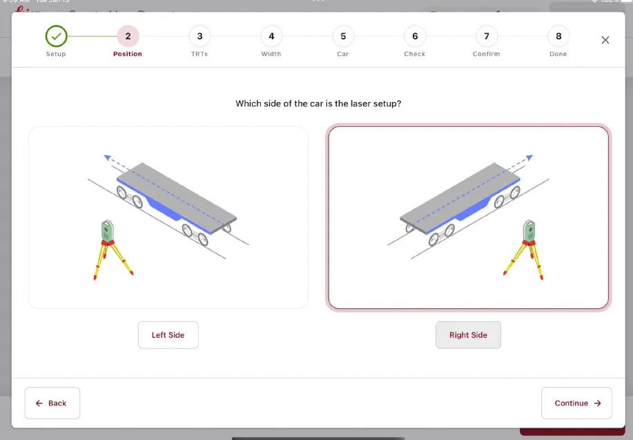 Click to zoom
The rebuilt step: high-contrast and step-guided, with full-image selection targets and the same measurement logic underneath.
Three platforms, without compromising the core
We solved the integration problem, not just the interface.
- One unified codebase across iOS, Android, Windows
- Connectivity rebuilt for Bluetooth and WiFi
- 19-asset in-app Total Station setup guide
Workflow improvements that protect compliance continuity
More flexibility for crews, with compliance checked at every step.
- Parallel reports, hold one, start another, lose nothing
- Free navigation; resume directly after any interruption
- Every change evaluated for compliance impact before launch
License management built for a growing customer base
The infrastructure foundation for a scaling, multi-platform deployment.
- Central view of activations and transfers
- Self-service device transfers, no support ticket
- Visibility across every device type and platform
Validated against a live Total Station, not just a demo build.
A tool that passes in a studio can still fail trackside. So we tested where the work happens.
We ran a real-world trial on an actual Total Station with the Leica Geosystems team, comparing the rebuilt app’s outputs against the legacy app step by step.
- New-vs-legacy output verified for each measurement step
- Width-calculation and laser-movement workflows refined from field-trial findings
- Connectivity validated on real WiFi in the field, not just a studio network
- Report PDFs polished for consistency before launch
 Click to zoom
Investigate before you estimate: validating the rebuilt app against a live Total Station, trackside, before launch.
Business value delivered: a bigger market, a lower cost to serve, and an installed base defended.
Safeload now runs on iOS, Android, and Windows, with the compliance integrity and measurement precision that built its reputation fully preserved. For Leica Geosystems, the rebuild changes the commercial picture: the platform barrier that kept iOS and Android field operations out of reach is gone, every Safeload deployment carries Total Station hardware with it, and license administration that used to route through support is now self-service.
Commercial Impact
Field operations running iOS or Android, previously excluded by the Windows-only build, are now sellable. The product’s biggest sales barrier is gone.
Every Safeload deployment pairs with Leica Geosystems Total Station instruments, modern software protects and extends Leica Geosystems’s hardware position in rail.
The rail customers who asked for iOS keep a tool they already trust, two decades of compliance reputation carried forward, not put at risk.
A central License Management System gives Leica Geosystems the foundation to grow and manage a multi-platform customer base.
Operational Impact
License transfers that used to route through Leica Geosystems support are now self-service, less friction for crews, less overhead for Leica Geosystems’s team.
A 19-asset in-app guide gets crews connected to the Total Station without a support call.
Parallel reports and free navigation replace start-over-from-the-beginning workflows, interruptions no longer cost a full re-walk.
Regulated outputs and measurement precision carry through untouched.
The product that earned two decades of trust in the rail industry is now built to earn two more.
Explore Safeload.
Safeload is Leica Geosystems’ laser-based measurement and documentation system for high-value, high-risk dimensional loads. Watch it work, then dig into the full product brochure.
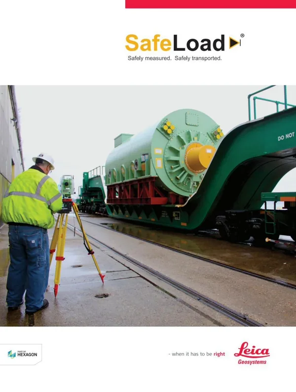
The Safeload brochure
Product specifications, measurement workflow, and hardware pairing, direct from Leica Geosystems.
View the Safeload Brochure (PDF)If you’re evaluating a modernization partner, ask about judgment, not just capability.
If you’re in a regulated industry with established software that needs to evolve, the questions worth asking aren’t only about technical skill. They’re about judgment.
Do they understand what can’t change, and why?
Modernization in regulated environments isn’t about replacing everything. It’s identifying what carries compliance weight, operational trust, or institutional knowledge, and treating that as a constraint, not a starting point for redesign.
Do they investigate before they estimate?
Mature software almost always has architectural complexity beneath the surface. The right partner surfaces it early, before it becomes a project risk.
Do they design for the actual user, in the actual environment?
Field teams work in conditions that don’t resemble a product demo. Decisions that ignore gloves, sunlight, intermittent connectivity, and interrupted workflows create tools that fail in the field.
Can they sequence the work to manage risk?
The order of operations matters. Workflow logic, compliance outputs, and hardware integration each carry different risk profiles and need to be phased accordingly.
These are the questions Digital Scientists is built to answer, and the capabilities we brought to Safeload.
Explore Platform Modernization

Have established software that needs to evolve?
High-stakes modernization is what we’re built for. We investigate before we estimate, preserve what carries trust, and stay to make it better. Let’s scope yours.
Since 2007 · 200+ products launched · One team, concept to scale